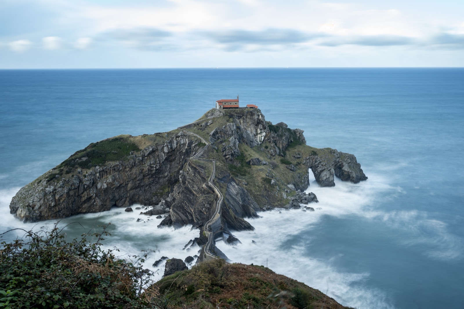
Gaztelugatxe Hike: The Coast Path from Bakio to Cape Matxitxako
You do not have to drive to Gaztelugatxe and walk straight down. A waymarked coast path, the Senda Gaztelugatxe, runs 5.6 km from Bakio to the Matxitxako lighthouse, passing the Urizarreta and Ermu entrances to the islet and the Lurgorri recreation area on the way. The first two kilometres, from the Bakio viewpoint to the Urizarreta access, are the stretch most visitors walk; the rest continues along the cliffs to the northernmost cape of the Basque coast. Add the descent to the bridge and the 241 steps to the hermitage, and you have one of the finest coastal walks in Bizkaia. This guide explains the route, the detour to the islet, the lighthouses at the end and how to get back.
The route at a glance
- Name: Senda Gaztelugatxe, the Bakio–Matxitxako footpath.
- Length: 5.6 km one way, from Bakio to the Matxitxako lighthouse, by way of Urizarreta.
- Waymarking: 20 waymarks along the route, through Urizarreta, Ermu and Lurgorri.
- Start: the Azkada viewpoint in Bakio.
- End: the Matxitxako lighthouse, in the municipality of Bermeo.
- Detour: from Urizarreta down to the bridge and up the 241 steps to the hermitage, returning by Ermu.
- Rules: a protected Natural Monument; no drones, camping, fires or litter.
How the path came about
For years most visitors arrived by car and parked wherever they could; on busy days more than 200 vehicles were counted on the road verges near Gaztelugatxe, although parking there is banned. To change that, the provincial council set about creating a pedestrian route along the coast. In 2019 it announced that it would signpost the stretch from the Azkada viewpoint in Bakio to the Matxitxako lighthouse in Bermeo, with 20 waymarks along the 5.6 km through Urizarreta, Ermu and Lurgorri. A second phase was planned to link the lighthouse with the centre of Bermeo.
Today the council itself recommends the path. It points out that the car parks are usually full, especially between 10:00 and 16:00, and suggests parking in Bakio or Bermeo and taking the bus or walking.
Starting in Bakio
Bakio is a small coastal town of 2,781 inhabitants, in the Uribe Butrón district between Mungia and Bermeo. It makes a pleasant start:
- The beach. Bakio’s beach has a long promenade running its whole length. It is an open beach with waves almost all year, a local surf club and two surf schools.
- The viewpoints. The Azkada and Jata viewpoints give exceptional panoramic views of Bakio.
- Txakoli. Bakio has a txakoli museum, Txakolingunea, devoted to the local white wine.
The path leaves from the Azkada viewpoint, called the Bakio viewpoint on the provincial council’s page. If you arrive by bus from Bilbao, line A3518 (Bilbao–Mungia–Bakio) brings you into the town.
Bakio to Urizarreta
The provincial council describes the first section in glowing terms. From the Bakio viewpoint the Bakio–Matxitxako footpath runs parallel to the coast and after two kilometres reaches the Urizarreta access to Gaztelugatxe. Along the way you look down on a coast of cliffs, islets and coves, with Gaztelugatxe and the zigzag of its stairway coming into view ahead.
Near Bakio, the council singles out the Atxulo area, where the waves have shaped remarkable underwater landscapes and many caves. Further on, the slopes are covered with Cantabrian holm oak and coastal heath, both rich in wildlife.
Urizarreta is the main entrance to the islet, near the Eneperi restaurant. You will find the public information point, toilets and, on controlled days, the staff who check tickets. There is also a small public car park of 22 spaces, usually full in the middle of the day.
The detour to the hermitage
From Urizarreta, most walkers make the detour down to the islet. Note that on controlled-access days you need a free ticket booked in advance, even if you arrive on foot. Our guide to access and the 241 steps explains the booking.
The detour follows the council’s one-way system:
- Down from Urizarreta: a very steep path of 1,200 m with a 35% gradient. Gernika’s tourist office says it takes about 45 minutes to reach the hermitage.
- The bridge and the steps: a stone bridge, then a stairway of 241 steps zigzagging up to the hermitage at the top.
- Back by Ermu: 1,600 m with a 15% gradient, a gentler climb back up to the coast path.
The provincial council says the visit takes about two and a half hours. That is a sensible figure to add to your walking time if you make the detour.
Bizkaia’s tourism site suggests bringing a hamaiketako, the Basque mid-morning snack, for the walk, and there are picnic tables along the Ermu route.
Ermu to Lurgorri
Coming back up by the Ermu route brings you out at the Ermu access control, which has the second set of toilets on the site. From here the coast path continues east towards Cape Matxitxako.
The Ermu route also has a viewpoint over the islet. The provincial council suggests that visitors with some kinds of physical disability enjoy the views from there, since the path down to the bridge is not suitable for them.
A little further on is the Lurgorri recreation area, which the council says you pass on the path from Matxitxako. It has a car park with 57 spaces, about 15 minutes’ walk from the Ermu access control. If you want a shorter walk, Lurgorri is a good place to start or finish: you can walk from there to Ermu and do the visit in reverse.
Lurgorri to Cape Matxitxako
The last section runs along the coast to Cape Matxitxako, the northernmost point of the Basque coast. The cliffs here are battered by sea and wind, and the provincial council notes that they hold populations of Armeria euskadiensis, a plant found only on the Basque coast, and wild olive, the wild ancestor of the olive tree.
Behind you, the view back to Gaztelugatxe and Akatx islet is one of the best of the walk. Bermeo’s tourism site says the islet path itself has small viewpoints along the way and that the spring sunsets there are incredible.
The Matxitxako lighthouses
Cape Matxitxako has two lighthouses, and the walk ends between them.
The old lighthouse. Only the tower still stands. It was inaugurated on 21 August 1852, built of ashlar from the Duranguesado quarries, and was a first-order light, the longest-reaching of its day, at 23 nautical miles. It worked until the new light replaced it. Bizkaia’s tourism site says the old lighthouse is now an observatory for seabirds and cetaceans.
The new lighthouse. The current lighthouse, 110 metres to the south, was inaugurated in 1909 and was the work of the engineer Rafael de La Cerda. It shows a white flash every 7 seconds with a range of 35 nautical miles, its light 122 metres above sea level. It also served as a school for lighthouse keepers, and it is still working. The interior cannot be visited.
From the cape, Bizkaia’s tourism site says, San Juan de Gaztelugatxe lies to the west, and the island of Izaro and Ogoño to the east.
Wildlife on the way
This stretch of coast is part of a protected area, and it is rich in wildlife:
- Cetaceans. From summer to autumn Cape Matxitxako is an ideal place to watch cetaceans: dolphins, sperm whales, rorquals, pilot whales, orcas and humpbacks.
- Seabirds. Akatx islet is a sanctuary for seabirds. The storm petrel nesting there is very hard to see except in strong storms, when it comes close to the coast for shelter. Yellow-legged gulls, shags and peregrine falcons also stand out.
- Migrants. The cape is a good observatory for birds on migration.
Bring binoculars if you have them, and keep to the path: the cliffs and the nesting sites are the reason the area is protected.
Shipwrecks and battles off the cape
The sea off Matxitxako has a grim history. At midday on Holy Saturday 1878, a hurricane capsized 14 boats and 3 small craft, and 85 Bermeo sailors drowned. On the night of 12 to 13 August 1912, a galerna storm killed 116 people from Bermeo. In the naval battle of 5 March 1937, 35 sailors of the Basque Navy died fighting the rebel cruiser Canarias. On the cape you can still find the old Civil War gun battery, the watchtower and the powder store.
Reaching Matxitxako by road
If you prefer to see the lighthouses without the whole walk, you can drive. From the Bermeo–Bakio road, past the Altamira-Gibale district, the first turning right towards Arribolas beach leads to the lighthouse promontory, just 1.8 km from the junction.
Bizkaia’s tourism site says you can drive right to the lighthouse. Alternatively, park at the start of the road: the stretch down from the Arene district is 2.56 km of asphalt with a 30 km/h limit and priority for pedestrians. It is a long, gentle slope, which makes it manageable in a wheelchair with help, but it is tiring on the way back. There are no adapted public toilets at the lighthouse.
Basque Tourism describes a shorter way in on foot: take the BI-3101 from Bermeo through Arene, and at the gasworks there is an area on the right where you can park. From there a path goes down to the lighthouse, but the climb back is quite steep.
Getting back
The path is linear, so plan the return before you set off. The options are:
- Walk back the way you came. This is the simplest, and the views are just as good in reverse.
- Take the bus. Bus A3527 (Bilbao–Mungia–Bermeo) stops at San Juan de Gaztelugatxe. Between Bakio and Bermeo, the bus is line A3517 in summer and A3524 in winter, and from Bermeo and Bakio you can also take the taxibus, which carries at most 8 people.
- Leave a car at each end, if you are walking in a group.
Check timetables before you go, especially out of season.
Planning your walk
A few practical points:
- Footwear and water. The provincial council stresses comfortable clothes and footwear, water and, in summer, sun cream.
- Toilets. On the Gaztelugatxe section there are toilets only at the Urizarreta information point and the Ermu control point.
- Time of day. Midday is the busiest time at the islet. Start early, or plan to reach Gaztelugatxe late in the afternoon.
- Weather. Check the forecast; on orange-alert days the council recommends not climbing to the hermitage during the hours affected. Our weather page has a live forecast.
- Fitness. The coast path itself undulates, but the detour to the hermitage is the hard part. The council says it is not advisable for people with health problems or difficulty walking, nor with pushchairs.
Walking in different seasons
The path is open all year, but each season changes the walk:
- Spring. Green slopes, longer days and, according to Bermeo’s tourism site, incredible sunsets at Gaztelugatxe. Easter and spring weekends are busy at the islet.
- Summer. The warmest and busiest season. Access to the islet is controlled every day, so book your ticket, start early and bring sun cream and plenty of water.
- Autumn. Quieter weekdays and the best chance of spotting cetaceans from Cape Matxitxako, which is ideal for watching them from summer to autumn.
- Winter. The fewest people and the wildest sea. Days are short, so start in good time, and take care on wet steps.
Our guide to the best time to visit has the ticket calendar and the days to avoid.
Eating and drinking on the way
There is little along the path itself, so plan ahead. Bakio, at the start, has cafés and restaurants, and Bizkaia’s tourism site mentions the restaurant facing the hermitage; the Eneperi restaurant, where the Urizarreta route starts, also has a viewpoint in its gardens. In Bakio, Bermeo and Mundaka you will find restaurants with local menus; the tourism site suggests marmitako, a stew of bonito with potatoes, onion, pepper and tomato, with a glass of Bizkaia txakoli. For the walk itself, pack a snack and refill your water before you set off.
Rules on the path
Remember that you are in a protected Natural Monument. Camping, climbing, fires, noise, litter, diving, driving or parking outside marked places and flying drones are not allowed. Take your rubbish home, keep dogs under control and do not pick plants. The council asks visitors to leave no trace but the memory and the wish to come back.
Choosing your version of the walk
- Short: Bakio to Urizarreta and back, two kilometres each way, with the hermitage detour if you have a ticket.
- Classic: Bakio to Urizarreta, down to the hermitage, up by Ermu and on to Lurgorri, then back.
- Full: the whole 5.6 km from Bakio to the Matxitxako lighthouse, with the hermitage detour, returning by bus or on foot.
- Lighthouse only: drive or walk from Arene to Matxitxako for the views and the sunset.
Bermeo’s tourism site recommends staying at Matxitxako to watch the sun set; if you do, bring a torch for the walk back.
With a guide
If you would rather not organise the logistics, the small-group tours from Bilbao include one that pairs Gaztelugatxe with a walk along the Basque coast, in about 3.5 hours. Our guides to getting to Gaztelugatxe and the best time to visit cover the rest of your planning.
Frequently asked questions
Can you walk to Gaztelugatxe from Bakio?
Yes. The Bakio–Matxitxako footpath starts at the Bakio viewpoint and reaches the Urizarreta access to Gaztelugatxe after two kilometres.
How long is the Gaztelugatxe coast path?
The Senda Gaztelugatxe runs 5.6 km one way, from Bakio to the Matxitxako lighthouse, through Urizarreta, Ermu and Lurgorri.
Do I need a ticket if I walk there?
On controlled-access days, yes: the ticket is needed to go down to the islet, however you arrive. On other days access is free.
Can I visit the Matxitxako lighthouse?
You can walk or drive to it and enjoy the views, but the interior cannot be visited.
Is the walk suitable for children?
The coast path is fine for active families. The detour to the hermitage is steep and not suitable for pushchairs.
Where can I see whales?
Cape Matxitxako is an ideal place to watch cetaceans from summer to autumn. For a closer look, whale-watching trips leave from Bermeo; see our boat trip guide.